
If the Route 66 implied the cognitive perception of a linear country, the Interstate Highway System cemented it. In use by 1926, the Route 66 served as a major path for those who migrated west, and it supported the economies of the communities through which the road passed, as tourism and expansion flourished. Many towns therefore grew up and thrived with the Route 66, their businesses adorning either side of its unremitting span while benefitted by its uniquely American character.
In typical American fashion, the highway saw two distinct types of small towns: those that mythologically heightened their cultural credibility in an attempt to act as edified landmarks along its fabled route, and those that insisted on general indifference towards it in the name of their original small-town modesty, often as farming communities. In other words, extroverted towns and introverted towns. The Route 66 catered to the interests of these two town types with very simple maneuvers, either with varied asphalt gradings (determining the speed at which automobiles would drive through towns) or the placement of businesses on either side of the highway. But, as Keller Easterling wrote in Organization Space, “Many highway histories have treated the interstate as a predestined event in a patriotic saga, though the more contentious histories have usually taken an entrenched position against the villainous collision between federal agencies and private automobile interests.”[1] In other words, the Interstate Highway System proved to be a potential threat to the towns it would bypass, and the future of those towns, as well as their surviving features and characteristics, would be compromised by the new country-spanning infrastructure.
By the time the Interstate Highway System was initiated in 1956, many of the towns along the Route 66 were already in their post-development phase, reluctant to adapt to the newly incoming infrastructural system. The two town types attempted to hold on to their qualities as either introverted or extroverted in light of the new infrastructural system, resulting in characteristically 20th century strategies of infrastructural integration or disintegration. The intention of this essay is to reveal the varied negotiations and post-development relationships between the two small town types – in this essay typified by Santa Rosa, New Mexico as the former, and Canute, Oklahoma as the latter – and the country-sized Interstate Highway system; between the smallest and most outdated urban forms and the country’s largest piece of infrastructure.
BILLBOARDS
When the last portion of the Interstate 40 was laid down, Charles Kuralt, American television journalist, famously stated, “thanks to the interstate highway system, it is now possible to travel from coast to coast without seeing anything.”[2] As opposed to the Route 66’s designated average speed of 50 miles per hour, The Interstate Highway System’s average is around 70 (though, outside of legality, much higher speeds would go unquestioned). The gas mileage figures and average speeds of cars that frequented the original Route 66 were much lower than those by today’s standards, and the towns along the way were distanced appropriately from each other to accommodate these figures. But as the automobile industry improved its figures, engineers constantly sought more direct routes between cities and towns, causing fewer towns between to be frequented.
The cities that thrived off the tourist economy had to make their presence known in a post-Route 66 landscape. Santa Rosa created billboards along the Interstate, some of larger and more detailed food and gasoline messages than their Interstate-sanctioned equivalents, and others more varied and colorful, depicting the historical and material culture of the city itself, appearing as a place to be visited for more than just convenience.
Placed in a flat and desolate landscape, these billboards are the only cultural landmarks within several miles, perceptively making the town of Santa Rosa start much earlier than its true physical boundaries. Brochures advertising the city can be found in the vestibule of restaurants along the Interstate from Arizona to Oklahoma. Paul Virilio wrote that “the 20th century’s phrase “to go into town” replaces the 19th century’s “to go to town,” indicating the uncertainty of the encounter, as if we could no longer stand before the city but rather abide forever within.”[3] If the Interstate – the new “Main Street of America” – allows travelers to abide forever within one long and linear system, then Santa Rosa, through brochures and highway billboards, is an agent in blurring this distinction.
Canute struggled with the advent of the Interstate 40, and did little to advertise itself to the tourists beyond its physical limits. In a fit of introversion, the town does not ‘sell itself,’ choosing instead to be announced within a mere five minute radius from its boundary. Always a farming community, Canute had little to offer tourists outside of staple commodities, and never chose to sell itself beyond this fact. The perceptive boundaries, therefore, are not much further than the physical boundaries.
TOWN AND OBJECTHOOD
In their fixed positions, the towns along the interstate are more objects than towns. Since the Interstate Highway is the only feasible means to get to (or through) them, these towns clearly have a beginning and an end, a top and a bottom (if coming from the East, a town perceptually begins in the East. If from the West, the West).
The import and export conditions of these towns can be so easily diagrammed that, compared to larger towns, there is relatively little abstraction in their designs. Because of their likeness to objects, in their supposed simplicity and steady history, we can observe the two town types in their struggle to maintain or strengthen their identities in a way we simply can’t with cities of larger scales and types of peripheral infrastructure.
In its goal to generate revenue from tourists and truckers alike, Santa Rosa’s internal infrastructure and built environment is much more fluid and seemingly historical (much like the crooked streets of Amsterdam center) than its Canute-type counterpart. This aerially visible dynamism makes Santa Rosa slightly more difficult to call an ‘object’ than Canute, though remains in this category due to its size and ease of demographic diagramming.
The commercial/shopping district of Santa Rosa parallels the Interstate, and acts as a buffer between tourists and locals, whose houses are positioned directly behind it. The shops are spread out, yet there are constant reminders of its presence through billboards and seemingly culturally significant urban decorum.
Though many of the buildings that make up Santa Rosa are not historical and arguably insignificant, there are a few that were built prior to the Route 66 and have been restored and are now a vital presence in the commercial district. For example, the Guadalupe County Building, an old and meticulously designed courthouse, is placed rather inappropriately in the middle of the shopping area – no doubt an attempt to assimilate its visual character into the traveler’s cognitive perception of the town.[4] A new addition to the courthouse is in keeping with the desert vernacular, all embodying the notion of an ‘authentic’ small town.
Though Canute was founded in the early 1910’s, roughly the same time as Santa Rosa, there is little evidence today to support this fact as perception. There are seemingly no icons established within the town, there are no historic buildings (albeit a small cruciform in a park), and the character of the town is compromised by the onslaught of anonymous service stations, the only images available for the hurried traveler. Canute’s city hall is not the monument Santa Rosa’s so clearly aspires to be. It is a low-slung mixed use building: Part city hall, part clubhouse, part water department and part liquor store.[5] Unlike Santa Rosa, Canute is careful not to entice traveler’s to go further into their farming town, and this lack of present and evidentially historical artifacts or monuments is a fairly potent strategy.
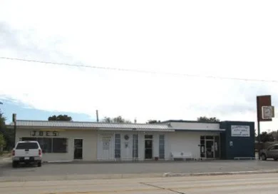
Canute City Hall
THE INSTERSTATE PARAMETRICALLY CONSIDERED
The Interstate was and is alien territory to those who attempt to assimilate it into the landscape. As Easterling notes, “It was not property, and it was neither cultivated or preserved. By the 1960’s, it was perceived as a kind of nonsite or a site that was fused to the roadway as a consequence of traffic engineering.”[6]
As mentioned earlier, the towns along the Interstate Highway have to fervently advertise their services in order to gain the attention of the cross-country traveler. Aside from the use of billboards, there is a clear advantage the traveler will have in viewing and understanding the character of the towns he passes, since the Interstate Highway is often elevated above the ground plane of the towns it passes through. This visual advantage, however, is balanced by the average Interstate traveler’s high speeds and obligation to get to a predetermined destination. Therefore, the small towns that either want attention or to be left alone both have to have well considered relationships with the Interstate Highway.
“The road makes things beautiful; by limiting exposure to a flash, it makes them mysterious.” -Philip Nobel[7]
Arizona and New Mexico are the only two states where the Interstate 40 has a speed limit of 75 mph instead of 70.[8] Afraid that this higher speed limit would lower traveler attendance, many of the towns of the area, including Santa Rosa, made agreements with the developers of the Interstate 40 before it was built. This meant that the entirety of the interstate’s monotony would soon be compromised by the individual desires of small towns, therefore becoming parametrically considered.
According to the Interstate Guide, these towns were some of the first to “sort out an agreement with state and federal officials in determining the locations of their I-40 bypasses as close to their business areas as possible, in order to permit easy access for highway travelers to their localities.”[9] Santa Rosa was given two exits off the I-40, yet they are strategically placed at the beginning and end of the main street of the town, which provides restaurants, motels, and other services to travelers.
As mentioned before, this street runs parallel to the I-40 and through the entirety of the town; on the west side of its stretch it is south of the I-40, and as it makes its way east it gradually makes its way north of it. Seen in aerial view, the town appears enmeshed in the Interstate’s spider web, the two almost indistinguishable from each other. From the highway, this commercial street is visible as one drives through the entirety of the town, and appears less a detour than something ‘on the way.’
Canute’s relationship with the Interstate, on the other hand, is much less refined. The shape of the I-40 is more or less maintained as it enters the boundary of Canute, shifting to the north slightly to provide some space between itself and the town. Unlike Santa Rosa, there is only one exit provided for the town, and it appears to have a very minor interaction with the town, without a grand entrance or exit ramp. Keller Easterling writes “while the highway was understood to be an evacuation facility for towns in times of war, it had the adverse effect of concentrating populations in those very towns.”[10] Canute is exemplary of such towns, with an exit/entrance ramp that creates an inefficient bottleneck effect, not adjusted to a fluid and dynamic circulation. If entering the town for services, they are at the foot of the exit, then prompting the traveler to turn around and proceed to the exit ramp.
In other words, the relationship between the I-40 and Santa Rosa allows the traveler to enter and exit the town in one smooth and fluid motion, whereas the same relationship between itself and Canute only allows the traveler to enter into the northernmost part of the town, only to then turn around and use the same designated bypass to exit. This reveals, once more, the difference between driving ‘through’ and driving ‘to’ a town.
_ _ _ _ _ _ _ _ _ _ _ _ _ _ _ _ _ _ _ _ _ _ _ _ _ _ _ _ _ _ _ _ _ _ _ _ _ _ _ _ _ _
By themselves, the small towns of America can be prided as hot spots in an otherwise rugged and desolate expanse; achievements in and of themselves. The Interstate Highway, always present in the landscape and the horizon, however, has spelled either trouble or financial success to these towns, whose character and goals were developed well before its arrival. The many ways in which they deal with or approach the highway, either as nuisance or economic opportunity, are successful in their goals, and through their characteristically 20thcentury strategies of inclusion or exclusion, they can maintain their identities as either introverted or extroverted towns; either with the superhighway or indifferent to it, but always read against it.
[1] Easterling, Keller. Organization Space: Landscapes, Highways, and Houses in America. 2. London: MIT Press, 1999. Print. Page 76
[2] Kuralt, Charles. “On the Road Again.” Slate. N.p., 2010. Web. 21 Nov 2011.<http://www.slate.com/articles/arts/dvdextras/2009/10/on_the_road_again.html>.
[3] Virilio, Paul. The Lost Dimension. 3rd. Los Angeles: Semiotext(e), 1991. Print. Page 34
[4] County Government. 2010. Web. <http://www.srnm.org/Government/Guadalupe-County.aspx>.
[5] GW Bill Miller. “Route 66 Roadtrip.” March 2009 < http://tulsagentleman.blogspot.com/2009/10/route-66-roadtrip-day-3-oklahoma-city.html>
[6] Easterling, Keller. Organization Space: Landscapes, Highways, and Houses in America. 2. London: MIT Press, 1999. Print. Page 112
[7] Nobel, Philip. “The Interstate – rejoice or recoil.” Metropolis Magazine. March 2000: Print. Page 36
[8] County Government. 2008. “Speed Limits of New Mexico” <http://www.iihs.org/laws/speedlimits.aspx>
[9] 2006 <http://www.interstate-guide.com>
[10] Easterling, Keller. Organization Space: Landscapes, Highways, and Houses in America. 2. London: MIT Press, 1999. Print. Page 78